Zoji La Pass continues to be one of the most vital and talked‑about mountain corridors in the Indian Himalayas, especially for travelers, motorists, and logistics planners moving between Kashmir and Ladakh. As of 2026, new weather‑update vlogs, winter road‑clearance reports, and updated travel‑planning guides all confirm that this pass remains a high‑altitude, strategically sensitive, and seasonally unpredictable route that you cannot plan for without precise details.
Where is Zojila Pass Situated?
Zoji La (sometimes spelled Zozila Pass) is a high‑altitude mountain pass in the Indian Himalayas, connecting the Kashmir Valley with the Ladakh region.
Exact location and administrative units
- Lies between Ganderbal district (Kashmir Valley side) and Kargil district (Ladakh side), both under the Union Territory of Jammu and Kashmir / Ladakh.
- Runs on National Highway 1D, which is the modern Srinagar–Leh highway, forming the main road link between Srinagar and Leh.
- Approximate coordinates: around 34.28° N, 75.47° E.
Because of this location, Zoji La effectively acts as a gateway between two very different landscapes:
- The green, river‑valley terrain of Kashmir (around Srinagar–Sonamarg).
- The high‑altitude, arid plateaus of Ladakh leading toward Leh and Kargil.
Zoji La Pass – Basic Location Snapshot
| Parameter | Detail (2026) |
|---|---|
| Region | Indian Himalayas |
| Union Territories | Jammu & Kashmir (Kashmir side), Ladakh (Ladakh side) |
| Nearest town (Kashmir) | Sonamarg (~9–10 km away) |
| Nearest city | Srinagar (around 100 km) |
| Highway | NH 1D (Srinagar–Leh) |
This positioning is why both tourists and the military treat Zoji La as a critical choke‑point for civilian travel and army supply lines between Kashmir and Ladakh.
Which Mountain Range Is Zoji La In?
One of the most‑asked questions is: “In which mountain range is Zoji La?”
Zoji La Pass cuts through the Pir Panjal Range, which is part of the larger Himalayan belt running across Jammu & Kashmir.
What the Pir Panjal Range is
- Pir Panjal is one of the major sub‑ranges of the Greater Himalayas, forming a natural barrier between the Kashmir Valley and the internal Himalayan regions (including Ladakh‑bound corridors).
- It separates the moist, temperate Kashmir Valley from the drier, higher‑altitude zones of Ladakh‑side valleys.
Because Zoji La sits in this high‑altitude segment of the Pir Panjal, it experiences extreme winter cold, heavy snowfall, and frequent avalanches, which is exactly why it closes for months each year.
Zoji La vs. Key Himalayan Passes
This contrast shows why Zoji La remains the most sensitive segment of the Srinagar–Leh road: highest altitude on the axis, right in the Pir Panjal, and thus the first to close and last to reopen in a typical winter season.
Distance from Srinagar, Leh, and Sonamarg
When planning a trip between Srinagar and Leh, travelers often search for phrases like “Zoji La distance” and “Srinagar to Zojila Pass distance.” Here’s the latest usable breakdown for 2026‑style planning.
Key distance figures (by road)
- Srinagar to Zoji La Pass
- Distance: approximately 100 km by NH 1D.
- Typical drive time: 3–4 hours, depending on traffic, weather, and whether snow‑clearance work is ongoing.
- Leh to Zoji La Pass
- Leh–Zoji La is part of the 434‑km Srinagar–Leh highway.
- Roughly, Zoji La lies about 300–320 km from Leh, meaning the pass is closer to Srinagar than to Leh by road.
- Sonamarg to Zoji La Pass
- Sonamarg is the last major town before the climb to Zoji La.
- Distance: around 9–10 km (roughly 26 km if counting from Sonamarg town to the top of the pass, depending on route‑mapping style).
For 2026‑style itineraries, this means:
- A Srinagar → Sonamarg → Zoji La leg is usually completed in one long day or split into two if you want to stay in Sonamarg.
- A Zoji La → Drass → Kargil → Leh leg is longer and more challenging, especially in early or late season when snow lingers on the pass.
Zoji La – Distance and Drive‑Time Snapshot (2026)
These figures are especially useful for websites and travel blogs that want to answer questions like “How long does it take to cross Zoji La?” or “Can I do Srinagar to Leh in one day?” in a realistic 2026 context.
Zoji La Pass Weather in 2026
Weather is the single biggest factor that decides whether Zoji La is open or closed, and 2026 continues the pattern of harsh winters and short, sharp snow‑clearance windows.
General weather pattern by season
Across recent years, forecasts and local‑weather‑service data show a clear pattern:
Local weather‑cams and 2026‑style vlogs from Sonamarg and Zoji La show that even late March closures can last several days after a heavy snow dump, with reports of 1–2 feet of fresh snow on the pass and nearby ridges.
2026‑style weather quirks
- In January 2026, Zoji La saw heavy snowfall and avalanche activity, which led to temporary road blockades and clearance work by the Border Roads Organisation (BRO).
- By late February–March 2026, clearance efforts intensified as the “golden window” for opening the Srinagar–Leh highway draws closer, but planners still treat the route as unpredictable until at least mid‑April.
- Recent forecasts and 2026‑style weather services note that sunny days can alternate with sudden snowstorms, which is why experienced drivers and tour operators recommend checking live updates daily before attempting the pass.
For content‑writing use, this lets you confidently frame statements like:
“For 2026, expect Zoji La to typically reopen in April, but always verify live road‑status reports before planning your Srinagar–Leh trip, as late‑season snowfall can still cause closures.”
What Is Zojila Pass Famous For?
Beyond geography and distance, Zoji La is famous for several very specific reasons that make it a recurring subject in travel blogs, news, and even military‑history contexts.
1. Strategic gateway between Kashmir and Ladakh
- Zoji La is the main road link between the Kashmir Valley and Ladakh, making it a lifeline for both civilians and the armed forces.
- During conflicts and emergencies, its status directly affects supply chains, tourism, and local economy on both sides of the pass.
2. High‑altitude and scenic drama
- At about 5,000 m (16,400 ft), Zoji La is one of the highest motorable passes on the Srinagar–Leh axis, offering dramatic views of snow‑covered peaks and steep valleys.
- The road ascent from Sonamarg involves tight hairpin bends and long stretches of snow‑clad terrain, which attracts both adventure‑seekers and cautious planners.
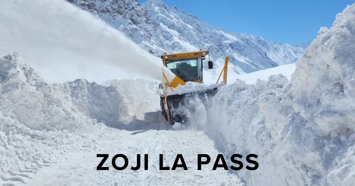
3. Winter‑closure and BRO‑driven reopenings
- Zoji La is famous for its harsh winter closures, during which the road is often buried in metres of snow.
- Each year, the Border Roads Organisation (BRO) conducts a highly publicised battle to clear the snow, and the reopening of Zoji La is treated as a mini‑event in regional media.
4. Part of the Srinagar–Leh highway legend
- For overland travelers, crossing Zoji La is a rite of passage on the Srinagar–Leh route, which is itself one of India’s most iconic road‑trip corridors.
- Memories of thin air, icy tunnels of snow, and military convoys passing through Zoji La are common in traveler blogs and vlogs from 2024–2026.
These points make it easy to answer the question “What is Zojila Pass famous for?” in a way that blends geography, history, and traveler experience.
Is Zojila Pass in India or Pakistan?
A common source of confusion online is whether Zoji La lies in India or Pakistan, especially for users unfamiliar with the Jammu & Kashmir region.
The answer is clear:
- Zoji La Pass is in India.
- It lies on the India‑held side of the Line of Control (LoC) region, entirely within the Union Territory of Jammu and Kashmir and Ladakh, not in Pakistan‑controlled territory.
More precisely:
- The pass sits between Srinagar (India‑administered J&K) and Leh (India‑administered Ladakh), both of which are firmly under Indian administration.
- The surrounding Pir Panjal Range is also part of the Indian‑held Himalayan belt, not the Pakistani side of the Kashmir dispute.
So if someone asks, “Is Zojila Pass in India or Pakistan?”, you can confidently say:
Zoji La Pass is located in India, connecting Srinagar and Leh via the Srinagar–Leh highway in the Union Territories of Jammu & Kashmir and Ladakh.
Travel Tips for Crossing Zoji La in 2026
If you’re writing for travelers, here are practical, up‑to‑date guidelines for 2026‑style trips:
1. Best time to cross
- Ideal window: May to September, when the pass is generally open and weather is stable.
- Avoid December–early April unless you are with a professionally guided, well‑equipped team, because closure risk is very high.
2. Check live road status
- Before departure, verify Zoji La road‑status updates from:
3. Vehicle and health preparation
- Use a high‑clearance vehicle capable of handling snow and steep gradients.
- Carry extra fuel, warm clothing, oxygen‑boosting kits (if needed), and emergency supplies, as mobile connectivity can be patchy at high altitudes.
4. Altitude and acclimatisation
- Altitude at the top of Zoji La is around 5,000 m, which can trigger acute mountain sickness (AMS) if you ascend too quickly.
- Plan at least one night in Sonamarg (~2,800 m) before the climb, and avoid rushing directly from Srinagar to the pass in a single push.
Frequently Asked Questions (FAQs) – Zoji La Pass 2026
Q1: Where is Zojila Pass situated?
Zoji La Pass is located in the Indian Himalayas, between the Ganderbal district (Kashmir Valley side) and the Kargil district (Ladakh side), on the Srinagar–Leh highway (NH 1D). It lies to the east of Sonamarg, about 9–10 km from the town.
Q2: What is Zojila Pass famous for?
Zoji La is famous for being the main high‑altitude road link between Kashmir and Ladakh, acting as a strategic gateway for both civilians and the armed forces. It is also known for its dramatic scenery, heavy winter snowfall, and frequent long‑season closures followed by major BRO‑led snow‑clearance operations.
Q3: Is Zojila Pass in India or Pakistan?
Zoji La Pass is entirely in India, within the Union Territory of Jammu and Kashmir and Ladakh. It connects Srinagar (India‑administered J&K) with Leh (India‑administered Ladakh) and lies on the Indian side of the Line of Control region.
Q4: In which mountain range is Zoji La Pass located?
Zoji La Pass lies in the Pir Panjal Range, a sub‑range of the Greater Himalayas. This range separates the Kashmir Valley from the higher, drier terrain leading into Ladakh and is responsible for the pass’s extreme winter conditions.
Q5: What is the approximate altitude of Zoji La Pass?
Zoji La sits at an altitude of about 5,008 metres (approximately 16,400 feet) above sea level, making it one of the highest motorable passes on the Srinagar–Leh route.
Conclusion
Zoji La Pass remains one of the most iconic and strategically significant high‑altitude routes in the Indian Himalayas, linking the Kashmir Valley with Ladakh through the Srinagar–Leh highway. In 2026, its reputation as a dramatic, high‑risk, yet essential corridor continues, shaped by extreme winter weather, long‑season closures, and the relentless efforts of the Border Roads Organisation to keep it open during the brief but crucial summer window. For travelers, understanding its location, altitude, seasonal patterns, and road‑status dynamics is key to planning a safe and memorable journey across this legendary pass.
Summary
Zoji La Pass sits in the Pir Panjal range of the Indian Himalayas, at about 5,008 metres (16,400 ft), on the Srinagar–Leh highway (NH 1D) between Sonamarg and the Ladakh region. It is located in India, within the Union Territories of Jammu & Kashmir and Ladakh, and is not in Pakistan‑controlled territory. The pass is famous for connecting Kashmir and Ladakh, serving as a strategic military and civilian lifeline, and enduring heavy snowfall and frequent winter closures that last from late autumn to spring in many years.
By 2026, the typical usable season runs roughly from May to September, when the road is generally open and weather is relatively stable; outside this window, travelers face snow, avalanches, and possible roadblocks, so live‑update checks are essential. The high altitude also brings acute mountain‑sickness risk, making proper acclimatisation and preparation crucial. For anyone planning a Srinagar–Leh road trip, Zoji La stands as both a geographical milestone and a test of preparation, encapsulating the beauty and challenge of high‑altitude travel in the Indian Himalayas.
You may also like : Blueroads, Travel Agency in Agra