Kharg Island, situated in the northern Persian Gulf, has emerged as the central theater of the ongoing 2026 military confrontation between the United States and Iran. Often described as Tehran’s “crown jewel” of energy infrastructure, the island’s unique combination of deep-water access and industrial capacity makes it the heartbeat of Iran’s economy.
Following the escalation of tensions in early 2026, the island has become the target of major U.S. military strikes, fundamentally altering the energy landscape of the region. This comprehensive guide provides an exhaustive look at the strategic importance, recent military history, geographic facts, and the global implications defining this critical maritime location.
The Strategic Importance of Kharg Island
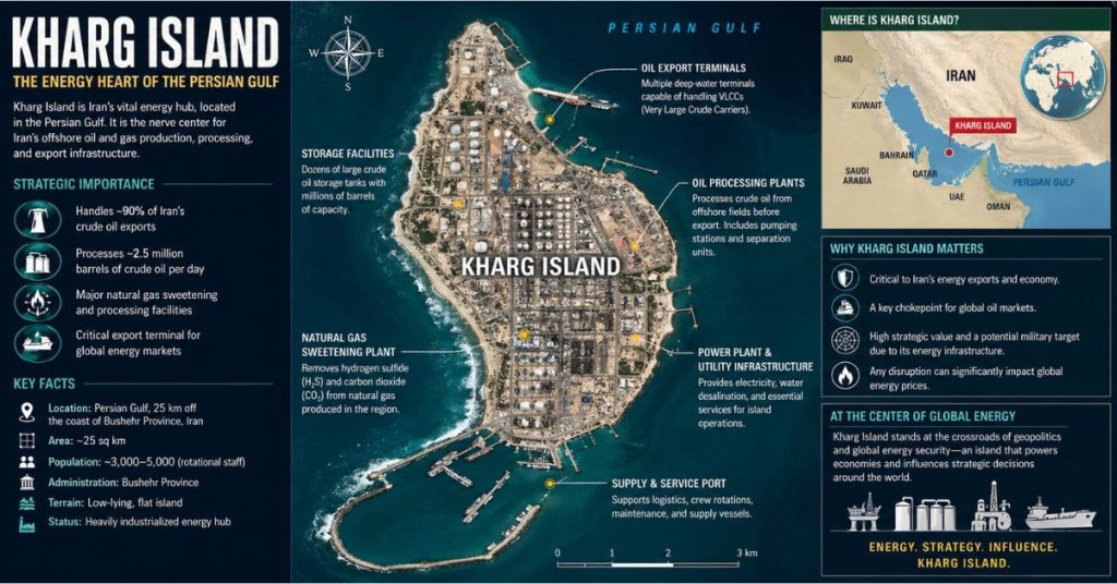
Kharg Island is not merely an island; it is the primary terminal for nearly 90 percent of Iran’s crude oil exports. Its ability to load up to 10 supertankers simultaneously, with a capacity of approximately 7 million barrels per day, makes it one of the most critical energy nodes in the global economy.
Why the Island is a Strategic Target
The island sits just 55 km (34 miles) off the coast of Bushehr, in waters deep enough to accommodate the world’s largest oil tankers. For the U.S. and its allies, Kharg represents both a critical pressure point and a military liability. It serves as a massive staging area for the Islamic Revolutionary Guard Corps (IRGC) to threaten shipping lanes through the Strait of Hormuz. By controlling Kharg, Iran maintains an “off-switch” for its own exports and a potential mechanism to influence global energy prices.
| Strategic Asset | Significance |
|---|---|
| Oil Export Capacity | Handles ~90% of Iran’s crude oil exports. |
| Global Energy Role | Key transit point for 20% of global oil/LNG shipments. |
| Military Utility | Staging base for naval mines and anti-ship missile batteries. |
| Geographic Advantage | Deep-water port suitable for supertanker operations. |
The 2026 Military Conflict: A Timeline of Strikes
The military status of Kharg Island changed drastically in early 2026. As hostilities intensified following blockades of the Strait of Hormuz, the U.S. launched a series of calculated strikes aimed at neutralizing Iranian military capabilities on the island without initially targeting the core oil infrastructure.
Key Events in the 2026 Conflict
- Early March 2026: Tensions boiled over as the IRGC signaled its intent to close the Strait of Hormuz. U.S. naval intelligence identified Kharg Island as the primary launch point for these operations.
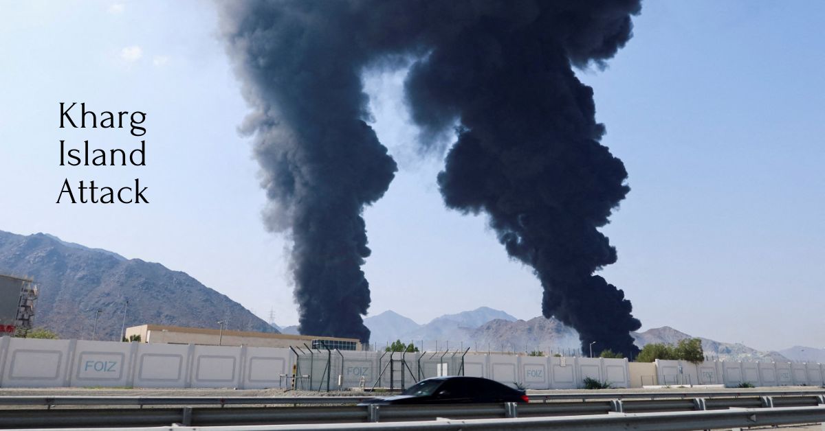
- March 14, 2026: In a decisive move, U.S. forces executed a large-scale strike on over 90 military targets on the island. This included sophisticated air defense facilities, naval drone bases, and primary command-and-control towers.
- April 2026 Escalation: Following continued hostilities and Iranian rocket fire, fresh U.S. strikes targeted secondary industrial assets and coastal radar installations on the island. These strikes signaled that the U.S. was no longer limiting its targets to purely “defensive” military assets.
- The “Indecency” Doctrine: Throughout the conflict, U.S. leadership, including President Donald Trump, explicitly stated that direct oil infrastructure (storage tanks and refineries) was exempted from strikes “for reasons of decency” to prevent a global energy collapse. However, this restraint remains fragile, and observers note that the island’s oil capacity is now the ultimate diplomatic leverage.
Geography and Population Facts
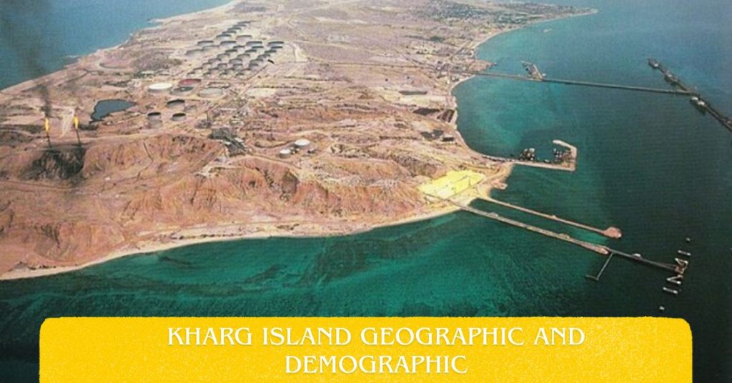
Beyond its industrial role, Kharg Island is geographically fascinating as one of the few islands in the Persian Gulf with natural freshwater resources, which has historically allowed it to sustain permanent settlements.
Geographic and Demographic Snapshot
| Data Point | Description |
|---|---|
| Location | 34 miles (55 km) northwest of Bushehr, Iran. |
| Area | Approximately 8.1 square miles (21 sq km). |
| Population | ~8,200 (mostly industrial/port workers). |
| Climate | Arid maritime, intense heat in summer months. |
The population of Kharg has fluctuated over the last several decades, heavily influenced by the industrialization of the island in the mid-20th century. During the Iran-Iraq War, the island was repeatedly targeted, which led to significant population shifts. Today, it functions as a highly specialized industrial city. The residents are primarily associated with the petroleum sector, meaning the island is less of a traditional “community” and more of a mission-critical logistics base.
Understanding the Kharg Island Map
A Kharg Island map provides context for its role in the current conflict. Positioned in the northern Persian Gulf, it sits along one of the most trafficked shipping routes in the world. The island is characterized by long loading piers that extend far into deep water, allowing for the massive logistics operations required for oil supertankers.
The infrastructure is tightly packed. From the north, the island contains the main loading berths; the central portion houses the mas
Kharg Island, situated in the northern Persian Gulf, has emerged as the central theater of the ongoing 2026 military confrontation between the United States and Iran. Often described as Tehran’s “crown jewel” of energy infrastructure, the island’s unique combination of deep-water access and industrial capacity makes it the heartbeat of Iran’s economy.
Following the escalation of tensions in early 2026, the island has become the target of major U.S. military strikes, fundamentally altering the energy landscape of the region. This comprehensive guide provides an exhaustive look at the strategic importance, recent military history, geographic facts, and the global implications defining this critical maritime location.
The Strategic Importance of Kharg Island
Kharg Island is not merely an island; it is the primary terminal for nearly 90 percent of Iran’s crude oil exports. Its ability to load up to 10 supertankers simultaneously, with a capacity of approximately 7 million barrels per day, makes it one of the most critical energy nodes in the global economy.
Why the Island is a Strategic Target
The island sits just 55 km (34 miles) off the coast of Bushehr, in waters deep enough to accommodate the world’s largest oil tankers. For the U.S. and its allies, Kharg represents both a critical pressure point and a military liability. It serves as a massive staging area for the Islamic Revolutionary Guard Corps (IRGC) to threaten shipping lanes through the Strait of Hormuz. By controlling Kharg, Iran maintains an “off-switch” for its own exports and a potential mechanism to influence global energy prices.
| Strategic Asset | Significance |
|---|---|
| Oil Export Capacity | Handles ~90% of Iran’s crude oil exports. |
| Global Energy Role | Key transit point for 20% of global oil/LNG shipments. |
| Military Utility | Staging base for naval mines and anti-ship missile batteries. |
| Geographic Advantage | Deep-water port suitable for supertanker operations. |
The 2026 Military Conflict: A Timeline of Strikes
The military status of Kharg Island changed drastically in early 2026. As hostilities intensified following blockades of the Strait of Hormuz, the U.S. launched a series of calculated strikes aimed at neutralizing Iranian military capabilities on the island without initially targeting the core oil infrastructure.
Key Events in the 2026 Conflict
- Early March 2026: Tensions boiled over as the IRGC signaled its intent to close the Strait of Hormuz. U.S. naval intelligence identified Kharg Island as the primary launch point for these operations.
- March 14, 2026: In a decisive move, U.S. forces executed a large-scale strike on over 90 military targets on the island. This included sophisticated air defense facilities, naval drone bases, and primary command-and-control towers.
- April 2026 Escalation: Following continued hostilities and Iranian rocket fire, fresh U.S. strikes targeted secondary industrial assets and coastal radar installations on the island. These strikes signaled that the U.S. was no longer limiting its targets to purely “defensive” military assets.
- The “Indecency” Doctrine: Throughout the conflict, U.S. leadership, including President Donald Trump, explicitly stated that direct oil infrastructure (storage tanks and refineries) was exempted from strikes “for reasons of decency” to prevent a global energy collapse. However, this restraint remains fragile, and observers note that the island’s oil capacity is now the ultimate diplomatic leverage.
Geography and Population Facts
Beyond its industrial role, Kharg Island is geographically fascinating as one of the few islands in the Persian Gulf with natural freshwater resources, which has historically allowed it to sustain permanent settlements.
Geographic and Demographic Snapshot
| Data Point | Description |
|---|---|
| Location | 34 miles (55 km) northwest of Bushehr, Iran. |
| Area | Approximately 8.1 square miles (21 sq km). |
| Population | ~8,200 (mostly industrial/port workers). |
| Climate | Arid maritime, intense heat in summer months. |
The population of Kharg has fluctuated over the last several decades, heavily influenced by the industrialization of the island in the mid-20th century. During the Iran-Iraq War, the island was repeatedly targeted, which led to significant population shifts. Today, it functions as a highly specialized industrial city. The residents are primarily associated with the petroleum sector, meaning the island is less of a traditional “community” and more of a mission-critical logistics base.
Understanding the Kharg Island Map
A Kharg Island map provides context for its role in the current conflict. Positioned in the northern Persian Gulf, it sits along one of the most trafficked shipping routes in the world. The island is characterized by long loading piers that extend far into deep water, allowing for the massive logistics operations required for oil supertankers.
The infrastructure is tightly packed. From the north, the island contains the main loading berths; the central portion houses the massive storage tank farms; and the southern end is historically home to the residential sectors and local airport.
Satellite imagery from early 2026 highlights the extensive infrastructure on Kharg Island, including oil storage tanks, port facilities, and a runway, all of which are focal points in current military intelligence assessments.
Strategic Proximity
The island’s location northwest of Bushehr provides it with a level of protection from the open sea, yet its proximity to the Strait of Hormuz makes it an ideal location for the deployment of anti-access/area-denial (A2/AD) weapons systems, such as naval mines and shore-based missiles.
Future Implications for Global Energy
The targeting of Kharg Island carries profound implications for the global economy. As a hub handling a significant portion of Iran’s crude output, any sustained disruption to the island’s facilities or the surrounding shipping lanes could lead to rapid, uncontrollable spikes in oil prices.
Market Vulnerability and Global Energy Security
The global markets are currently on “high alert.” Because Kharg Island handles the vast majority of Iranian crude, the international community views the island through two distinct lenses:
- The Energy Lens: The fear that a stray missile or a tactical escalation could incinerate the tank farms, effectively removing millions of barrels of oil from the global daily supply.
- The Military Lens: The realization that Kharg Island serves as a force-multiplier for the IRGC, allowing them to project power across the Persian Gulf.
The Balancing Act
The U.S. administration is currently performing a delicate balancing act: maintaining military pressure on Iran while ensuring that the “energy tap” in the Persian Gulf doesn’t run dry. However, as the 2026 conflict enters its second quarter, the “restraint” initially shown by the U.S. is becoming increasingly difficult to maintain as Iranian military posture remains aggressive.
Analyzing the 2026 Conflict Trajectory
The war in 2026 is distinct from any conflict seen in the region over the last thirty years. It is characterized by long-range precision strikes and digital intelligence warfare rather than traditional land-based infantry movements. Kharg Island is the centerpiece of this “technological attrition.”
The Technological Battlefield
The conflict has highlighted the importance of drones and electronic warfare. Many of the strikes on Kharg Island were facilitated by long-range, precision-guided munitions (PGMs) that can bypass Iranian anti-air defenses. This has forced the Iranian military to retreat into hardened bunkers and shift its command structures into subterranean facilities on the island.
Frequently Asked Questions
Has Kharg Island been attacked before 2026?
Yes, the island has been a strategic target in past conflicts, most notably during the Iran-Iraq War in the 1980s, where it suffered significant damage and was nicknamed the “Tanker War” epicenter.
What is the current status of the oil infrastructure?
As of late April 2026, U.S. strikes have largely focused on military facilities (air defense, naval bases, control towers) to avoid immediate global energy shocks, though oil infrastructure remains a threatened target.
Why is the island so important to Iran’s economy?
It serves as the terminal for nearly all of Iran’s oil exports, acting as the bridge between Iran’s domestic oil production and the global energy market.
Where exactly is it located?
It is situated in the northern part of the Persian Gulf, about 55 km northwest of the port of Bushehr, Iran.
Conclusion: The Barometer of Regional Stability
Kharg Island is no longer just an industrial asset; it is a global flashpoint. As the 2026 conflict continues, the island remains the ultimate indicator of the state of U.S.-Iran relations. If the strikes remain contained to military targets, the global economy can continue to function at its current pace. However, should the industrial heart of the island become a primary target, the resulting energy shock would be unparalleled in modern history.
As we look toward the remainder of 2026, observers worldwide remain focused on the skies over the Persian Gulf and the digital screens in military command centers, waiting to see what the next phase of the conflict will hold for this small but mighty piece of land.
- You may also like : Blueroads, Travel Agency in Agra
- Follow Us On : Facebook, Instagram